3.1 Logistics
Sampling should be conducted to minimize variation between sampling dates (Sections 2.3 and 2.4). Another way to minimize variation is to sample at the same time of day (photoperiod), tide height, and incoming versus outgoing tide. Each of these variables should be documented in your sampling records.
3.2 Transects
The transect and quadrat method is a very popular method in ecological science. This method relies on surveying a limited area of an ecosystem to get an approximate idea of the conditions for the entire ecosystem.
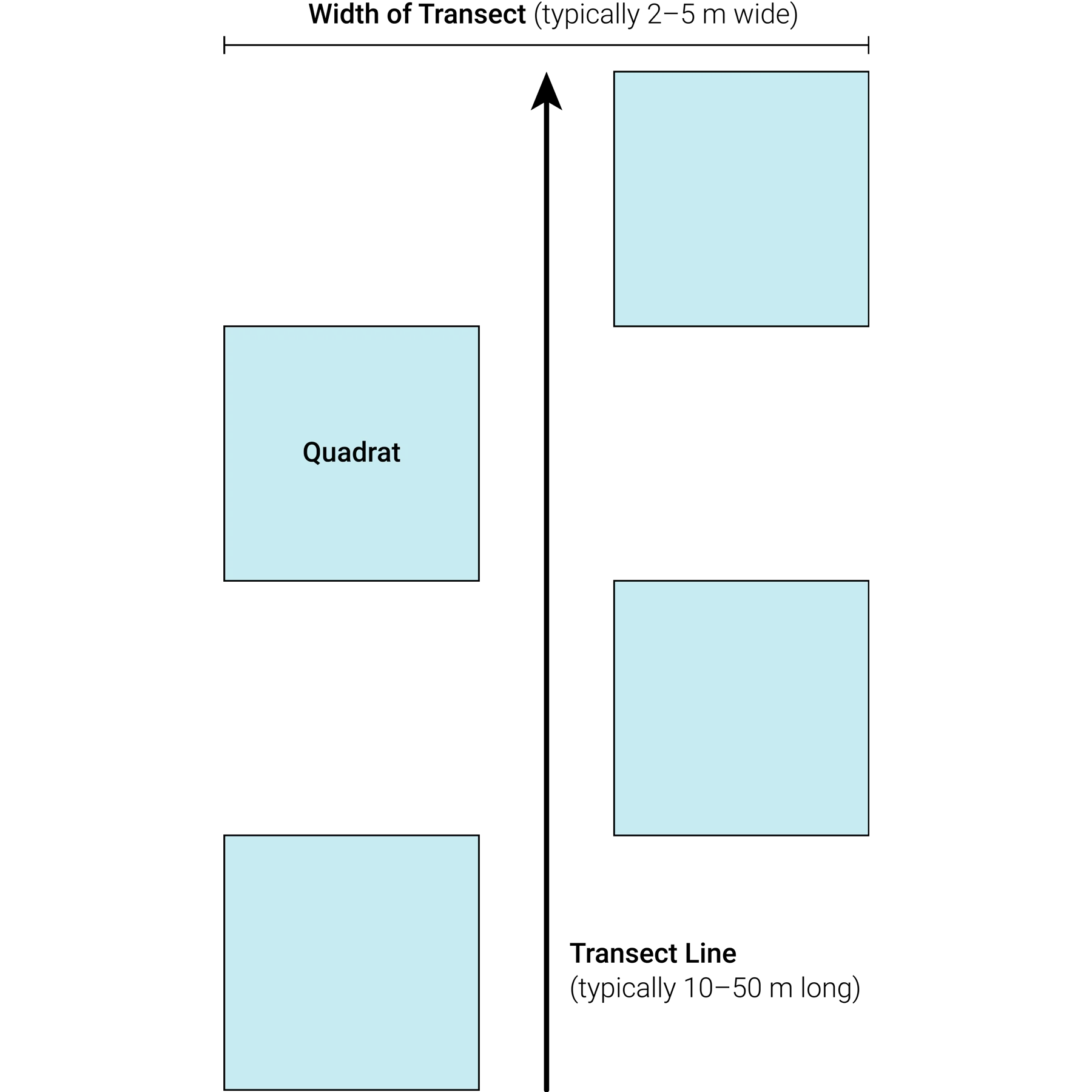
A transect is an area of the ecosystem used to observe or measure the natural environment. Transects typically vary between 10 and 50 metres (m) in length and are often paired with quadrats (Figure 4, Section 3.3). The task being completed will often determine how many transects you can safely fit in a dive survey performed with one tank of air. Transects are either limited by depth or air consumption, as slower or more deep tasks will allow for fewer or shorter transects per dive.
To define the area in which the user will record species, users must also identify the visual width of the transect. Typical widths are 2–5 m, depending on the visibility. If the visibility is less than this value, the transects should not be conducted.
Note that when completing visual surveys for pelagic and benthic biodiversity, we recommend conducting pelagic surveys before benthic surveys.
It is important that transects be surveyed in similar habitats at similar depths. Transects should be run over comparable sections of kelp forests and users are not surveying extremely different habitats, for example, 20 m of sand and 30 m of kelp. If you cannot find continuous habitat patches to run the transect, record which species were recorded in which habitat zone. Similarly, transects should be done at the same depth or similar depths. If you must vary the depth by transect, ensure that the depth of each transect is recorded.
3.2.1 Setting a Transect
Transects may be laid out using a spooled measuring tape or using a pre-measured, weighted line. The spooled measuring tape can only be laid out and retrieved in the water. The weighted line may be deployed or retrieved from the boat and is also more suitable in areas with high wave actions.
3.3 Quadrats
Quadrats are simply a square box that may be thought of as a sampling unit. Since it would take too much time to count every kelp or every fish in a kelp forest, we use quadrats to take standardized measures and make inferences about the unsurveyed areas. Quadrats are typically placed at set intervals along a transect (Figure 4) and the user either counts, estimates the area covered, or photographs the contents of the quadrats (i.e., what is laying inside of it). The size of the quadrat varies by what is being measured. If something is high in density or requires a high processing time per quadrat (e.g., removing all kelp biomass), users may select a smaller quadrat (10–25 centimetres [cm] in length and width, 0.01–0.0625 square metres [m2].) If the user is counting benthic invertebrates or taking a photo for later processing, they may wish to use a larger quadrat (25–100 cm in length and width, 0.0625–1 m2).
Figure 4. Diagram of a basic transect design
It is important to place the quadrat at the marked intervals along the transect. It may be tempting to shift the quadrat so there is more to count, but this movement will bias the sample and skew the results.
Users can also use quadrats to record depth and different substrate types across the transect.
3.4 Basic Tools
A transect tape is a measuring tape on a spool so that it can be reeled in and out while being laid across the seafloor.
A quadrat is usually made from one inch (2.4 cm) PVC tubing or rebar. These may have four sides or be simplified down to two sides to make them easier to place in complex marine environments.
3.4.1 Data Quality-Control and Management
All data should be checked for completeness in the field after it is collected. Users may also take a photograph of the datasheets to act as a backup. Ensure that all data records are digitized as soon as possible and stored with either a local backup or a cloud-based backup (Section 10.0).
Subsequent quality assurance and quality control (QA/QC) checks are an essential part of data management before analysis/reporting. QA/QC processes aim to eliminate errors that may occur when transcribing datasheets to a digital format. General procedures are outlined below:
Once data are collected, select a person to review datasheets in the field and ensure that everything is entered.
Enter data into a database or spreadsheet.
Always compare what is on the datasheets to what is in the database/spreadsheets and not the other way around.
Be sure to double-check every number so that missing values or values that were added accidentally can be identified and fixed.
When errors are found, make note of them, and correct them within the database. Keep all changes and notes in a separate spreadsheet as part of your records.
If needed, refer to the person who collected the data to resolve any discrepancies.Sampling should be conducted to minimize variation between sampling dates (Section on seasonal monitoring and BACI design). Variation may also be minimized by sampling at the same time of day (photoperiod), tide height, and incoming versus outgoing tide. Each of these variables should be documented in your sampling records.


