2.1 Objectives
When designing a monitoring program connected to a conservation intervention, there are several key concepts that are important to consider to help determine if the intervention resulted in the desired changes. Establishing clear objectives and using systematic and standardized monitoring protocols before and after the intervention are critical 1.
The motivations for a conservation intervention are to alter or maintain a key parameter, (e.g., maintain or increase kelp forest area or biodiversity, or reduce a problematic species). It is best practice to assess the selected parameters against a ‘reference’ ecosystem (e.g., healthy kelp forest density) or a preselected target (e.g., jobs created). Therefore, an important first step for any intervention is to identify the objectives or reference conditions that will determine success. A reference ecosystem or site will ideally be a healthy, local, natural kelp forest that has similar environmental parameters as the intervention site and is representative of the intervention objectives (e.g., contains the relevant species). Other objectives can be value-based but should be determined by what is desirable and achievable (e.g., water pollution concentrations, jobs created, tourism visits, research questions answered, etc.).
Defining clear objectives helps determine whether the desired outputs have been achieved or maintained. This ensures the most efficient use of monitoring resources and can aid adaptive management or flexible decision-making.
2.2 Monitoring period
Kelp forests are naturally dynamic ecosystems 2, and the outcomes of conservation interventions may take years to materialize (Figure 2). Monitoring programs should therefore be long-term and collect adequate information to make robust assessments about the impacts of conservation interventions (e.g., restoration, pollution clean-up, etc.) as well as the long-term condition of the ecosystem. If monitoring is related to a conservation intervention, monitoring should begin before the intervention and continue for a duration that encompasses short (less than one year) and medium-term (one to five years) goals, as the recovery of marine ecosystems and their associated services can take over a decade 3; 4. The duration of other monitoring projects depends on the project’s requirements. Whereas scientific research projects may only require a single season or year of data sampling, long-term monitoring programs assess and report on the ecosystem for decades.
Figure 2. Natural population dynamics of a kelp forest ecosystem.
2.3 Seasonality and monitoring
To ensure the accuracy of habitat monitoring programs, it’s important to consider the seasonality and frequency of sampling, which is sometimes overlooked. Natural variations in environmental and biological metrics can occur due to seasonal changes, leading to misinterpretation of impacts from restoration activities such as animal presence or changes in water quality. Seasonality also influences the kelp’s reproductive cycles, growth patterns, and perennial or annual survival. Therefore, monitoring of specific metrics should align with seasonal patterns and annual monitoring should take place at the same time each year. Additionally, monitoring frequency should be tailored to the metric being assessed. For instance, lower-frequency sampling, such as monthly or seasonal, may suffice for metrics like adult canopy cover. However, higher-frequency sampling, such as weekly monitoring, may be required for metrics where responses are more rapid or unknown, such as the survival of out-planted juvenile kelp.
Seasonal variation in ecosystem services varies across localities. However, as a general rule, you may expect to find certain seasonal patterns:
Spring: During this period of growth, which coincides with spawning season for some animals, kelp biomass may be high.
Summer: Biodiversity may be highest in summer as transient species move in with the warmer waters. Summertime may maintain high levels of growth, but high temperatures can cause stress and kelp die-off, notably in heatwave years.
Fall: In the fall, some kelp may experience a second round of growth as the water cools.
Winter: In the cold winter months, kelp grows at a very slow rate, but cool waters may support higher densities. Annual kelp will die off during this period. Late winter may be the start of the reproductive cycle.
2.4 Additionality and the Before-after-control-impact design
To assess the impact of a conservation intervention, monitoring should be conducted both before and after the intervention at the intervention site, as well as at a control site.
For kelp restoration or hypothesis testing, the control site should represent the pre-restoration conditions, typically an unrestored area or unimpacted site. This "Before-after-Control-Impact" (BACI) approach, combined with a reference site as a target, enables fair comparisons between different sites and their conditions over time, allowing for accurate evaluation of restoration effectiveness. This approach not only evaluates improvements at the restoration site but also assesses the trajectory of recovery and how the restored site performs relative to the reference site. To enable valid comparisons, control and natural reference sites should have similar physical characteristics to the restoration site, such as flow, wave action, tidal height, salinity, water temperature, substrate type and rugosity, and water depth. If it is not possible to match all the characteristics, we suggest prioritizing depth, exposure, and salinity. When pre-restoration monitoring is not feasible, comparing the restored and control sites becomes even more crucial, and findings should be supplemented with comparisons to a reference kelp forest, where possible.
Projects that are aimed at maintaining a parameter (e.g., biodiversity), mitigating a stressor (e.g., improving water quality), or simply monitoring conditions, may select to skip the reference site if it is deemed unnecessary for their project objectives.
2.5 Establishing project boundaries
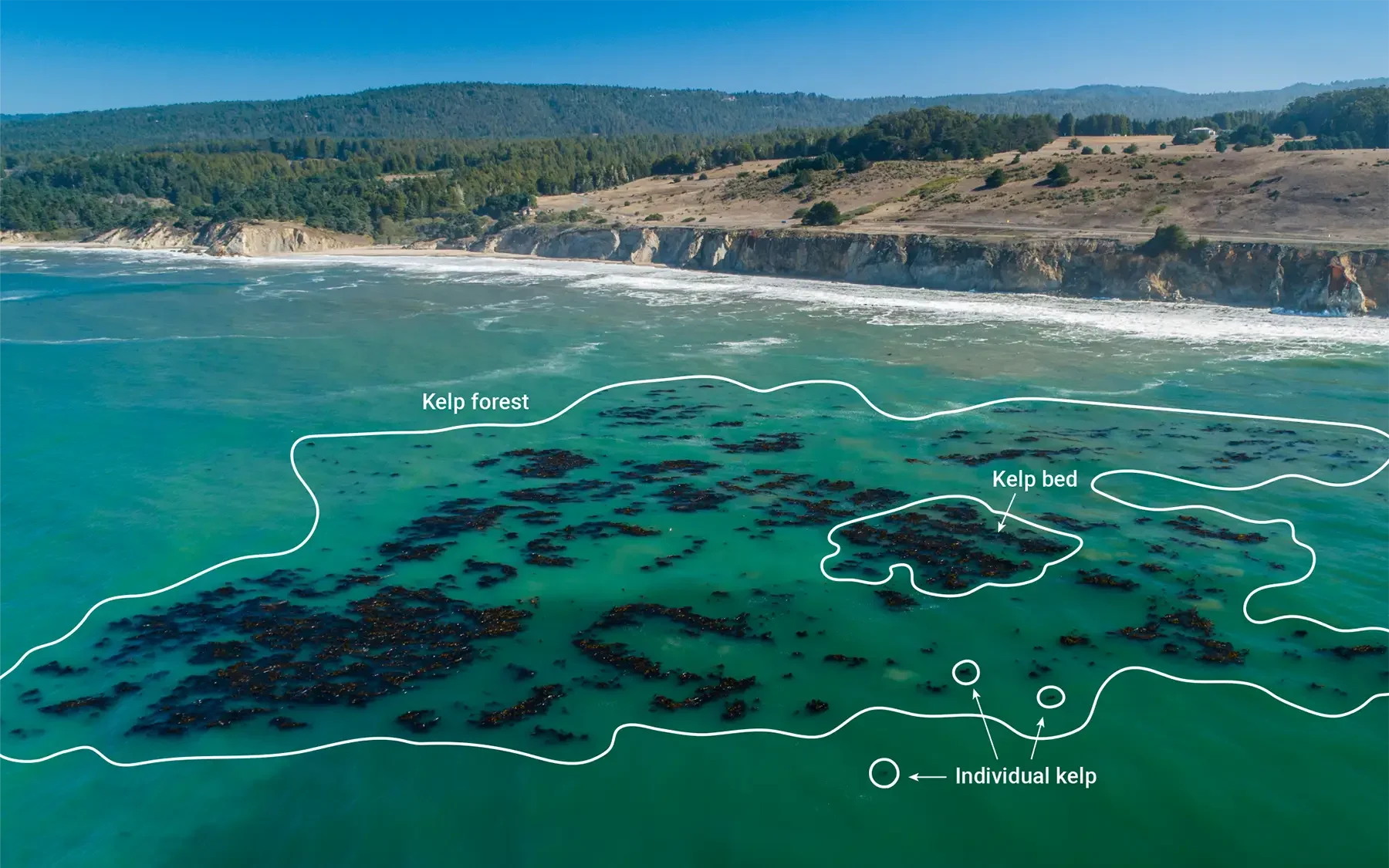
Before monitoring starts, it is important to delineate the site boundaries so that there is a clear definition of the monitoring area (Figure 3). This distinction will determine the space over which monitoring should occur and if project objectives have/have not been met. We recommend that all projects use discrete spatial units or management areas. Larger projects may combine these units for a more comprehensive assessment, but creating individual spatial units allows for more thorough consideration of the outcomes of the restoration project. A spatial unit may be a kelp forest at a distinct location or marine feature, such as a cove, bay, headland, jetty, beach, or contiguous coastline. These units should be defined using calibrated GPS coordinate systems.
Figure 3. Illustration of patch dynamics and kelp bed boundaries in kelp forest ecosystems
2.6 How to Use This Guide to Monitor a Kelp Forest
The core attributes of a kelp forest habitat can be broken into two elements: the extent and the condition. The extent refers to the size of the habitat (i.e., the area footprint), while the condition refers to the state (i.e., health of that habitat within the defined area). Monitoring both is required to robustly assess the outcomes of a restoration project. There are numerous variables that should be measured, but each additional measurement requires more time and resources. We recognize that not all projects will want or be able to measure all these variables. Projects should therefore consider which elements are most important to them and decide on a monitoring plan before starting restoration.
Costs are inevitably an important factor when determining which variables to monitor. The exact cost of monitoring will vary between years, regions, and approaches. Nevertheless, we provide rough approximations of the cost per hectare (ha) (Table 2) for the monitoring methods outlined in this document. These costs are then summarized at the end of each section.
Table 2. Relative and approximate costs of monitoring methods, standardized per hectare.
| Cost | USD per hectare (ha) |
|---|---|
| Low | < $1000 |
| Medium | $1000–2000 |
| High | $2000–5000 |
| Very High | > $5000 |
2.7 Six Key Parameters for Kelp Forest Monitoring
We recommend that every project monitor and record the “key parameters” when possible. These are the most valuable metrics assessing the extent and health of a kelp forest ecosystem, project success, and project inputs. Depending on their goals, projects may track additional parameters beyond these six. Users should see the sections below for information on additional parameters to monitor.
Users should also choose how often they wish to measure these parameters. We recommend endeavouring to capture seasonal variation if possible. If this is not possible, projects should compare values from the same season. We provide minimum monitoring suggestions below (Table 3). It is always better to have more sample points, but projects must balance this with higher costs. Consider that winter may have the lowest biomass, spring is a period of growth, summer may be exposed to extreme heat events, and that many species have seasonal variation in their reproduction.
Table 3. Key parameters and monitoring frequency.
| Parameter | Reason | Frequency (With intervention) | Frequency (Without intervention) |
|---|---|---|---|
| Area Extent | Understanding what size area you are monitoring. | Before intervention 2–4x/year in the first 2 years 1x/year after 2 years | 1–2x/year |
| Kelp Density | Understanding of the “health” of the kelp forest. | Before intervention At least 2x/year in the first 2 years 1x/year after 2 years | 1–2x/year |
| Biodiversity and Animal Density (Fish and Invertebrates) | Understanding of the species in a kelp forest as well as their productivity. | Before intervention 2–4x/year in the first 2 years 1x/year after 2 years | 1–2x/year |
| Water Temperature | A common stressor and cause of failure for restoration projects | Before intervention 2–4x/year in the first 2 years post intervention 1x/year after 2 years | 1–2x/year |
| Herbivore Population Size | A common stressor and cause of failure for restoration projects | Before intervention 2–4x/year in the first 2 years post intervention 1x/year after 2 years | 1–2x/year |
| Cost of Activity, Including People Employed in Conservation | An important factor to understand the resources required and the social benefits of restoration | 1x/year | 1–2x/year |
2.8 Workflow
Below are the details of a basic workflow for projects monitoring the six key parameters provided in Table 3.
Kelp Forest Extent
Canopy forming kelp (e.g., Macrocystis and Nereocystis)
Kelp forest is less than approximately 10 ha: On-water survey
Kelp forest is between 10 and 100 ha: Drone aerial survey
Kelp forest is > 100 ha: Satellite aerial imagery
Non-canopy forming kelp: visible from the surface
- On-water survey with a snorkeler to verify kelp boundaries
Non-canopy forming kelp: not visible from the surface
- SCUBA surveys if the kelp forest is < 4 ha
- Autonomous Underwater Vehicle (AUV) or drop camera surveys for kelp forests > 4 ha
Intertidal kelp
- Drone aerial survey
- On foot with a Global Positioning System (GPS) unit
Ecological Characteristics
Pelagic biodiversity
- Video (suggested minimum of 8 transects) or visual transect surveys (minimum of 2 transects)
Benthic biodiversity, sea urchin population, and kelp density
- Photo or visual quadrat surveys (suggested minimum of 8 minimum transects, 8 quadrats per transect)
Environmental Conditions
Establish baseline environmental conditions, prioritize as follows:
Use existing permanent sensors arrays (< 20 kilometres (km) from site)
Collect information from global data derived from satellites and models
If high accuracy is desired, install in water monitor for temperature, point samples for salinity and pH
Project Inputs
Dollars, including currency, spent on the project
- Salary
- Materials
- Capital costs (e.g., equipment, boats)
- Facility costs (e.g., lab fees)
Site Characteristics
These data help describe the ecological and physical characteristics of the site and help compare data across projects. Some characteristics of a site will not change over time and only need to be collected once. Projects should record:
- Maximum, minimum, and average depth of the site
- Wave exposure
- Substrate composition (e.g. rocks, pebbles, sand, etc.)
